Photo not mine: CTTO
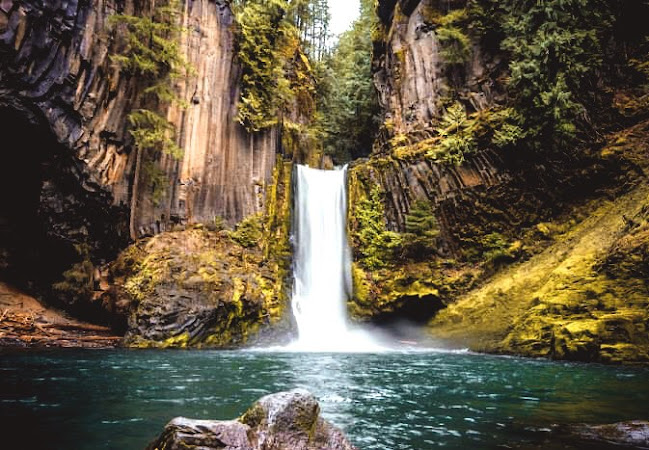
Toketee Falls is about 1.3-kilometer out-and-back trail close to Oregon's Idleyld Park. It requires an average of half an hour to finish and is typically a moderately challenging route. The relatively beautiful scenic view flanked by prominent basalt columns really made this waterfall stand out. One of Oregon's most well-known waterfalls, Toketee Falls is popular throughout the world for the lovely columnar basalt formation that surrounds the two-stepped falls.
Photo not mine: CTTO
Since hiking is highly popular in this region, you can run into other hikers while doing your exploration. It is ideal to hike on April through November. You will be surrounded by canyon cliffs and railings that provided hikers with great views of the North Umpqua River along this section of the trail.
Photo not mine: CTTO
Photo not mine: CTTO
Toketee Falls is a waterfall in Douglas County, Oregon, United States, on the North Umpqua River at its confluence with the Clearwater River. It is located approximately 58 miles (93 km) east of Roseburg near Oregon Route 138.
Toketee (pronounced TOKE-uh-tee), is a Chinook Jargon word meaning "pretty" or "graceful". The falls was officially named by a United States Board on Geographic Names decision in 1916, over alternate names Ireland Falls and Toketie Falls.
(Source: https://en.wikipedia.org/wiki/Toketee_Falls)
THE TRAIL
There are several areas you can
get down to the river and swim. The short out-and-back journey to the Toketee Falls viewing platform is only 0.79 miles roundtrip. Less than 100 feet of elevation are gained, which is hardly much. Dogs are permitted,
but they must be leashed. Picnic tables and toilets are available at the trailhead.
This trailhead leads to the majestic Toketee Falls on the 0.4-mile Toketee Falls Trail #1495. The North Umpqua River can be seen from multiple viewpoints. The trail leads to a platform in which the river can be seen cascading through a narrow gorge, forming a two-tiered falls. The upper descent drops 40 feet, and the lower falls plunges another 80 feet over a sheer wall of volcanic basalt.
AMENITIES
- Picnic tables
- Vault toilets
- No drinking water
- No garbage disposal - Please pack it out
GENERAL INFORMATION
Directions:
From Roseburg, OR turn onto OR-138 E / NE Diamond Lake Boulevard. Turn north off Highway 138 at milepost 58.6 onto Forest Road 34 (Toketee-Rigdon Road). Cross the first bridge and turn left to the trailhead parking. Trailhead is at the far end of the parking area.
Parking:
- Maximum number of vehicles: 10.
- No trailers allowed in the parking area.


0 Comments